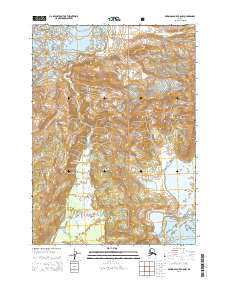
2014 Map of Bering Glacier B-8 NW
USGS Topo · Published 2014About this map
Chugach National Forest encompasses this high-altitude landscape where the massive Martin River Glacier and Steller Glacier dominate the northern and southern terrain. In the heart of the Chugach Mountains, the map reveals a complex hydrological network defined by the Bering River and its feeder, Canyon Cr. The interaction between these glacial flows and the surrounding peaks is evident in the formation of Berg Lake and the smaller Canyon Lake. Peaks such as Doughton Peak and Carbon Mountain rise sharply from the ice fields, while named ridgelines like Cunningham Ridge offer landmarks for navigators and surveyors. This 2014 survey documents the glacial extent and drainage patterns in a region defined by its extreme elevation and shifting ice, providing a clear record of the relationship between ice fields and river valleys.
Find a feature on this map
53 named features on this map. Tap any name to fly to it.
Don’t see what you’re looking for? This feature index may not catch every label — zoom into the map to look around manually.
Map Details
Editions of this 2014 Bering Glacier B-8 NW Map
This is the sole edition of this map. No revisions or reprints were ever made.
Other maps of this area

1948 · Cordova
USGS Topo · 1:250,000

1950 · Bering Glacier
USGS Topo · 1:250,000

1951 · Bering Glacier
USGS Topo · 1:250,000

1951 · Cordova
USGS Topo · 1:250,000

1951 · Cordova B-1
USGS Topo · 1:63,360

1953 · Cordova B-1
USGS Topo · 1:63,360

1959 · Cordova C-1
USGS Topo · 1:63,360

1959 · Bering Glacier
USGS Topo · 1:250,000

1959 · Cordova
USGS Topo · 1:250,000
1985 · Bering Glacier B-8
USGS Topo · 1:63,360