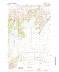
1985 Map of Bering Glacier B-8
USGS Topo · Published 1985About this map
Berg Lake serves as a central hydrological point in this frozen landscape, bordered by the massive Bering Glacier and Steller Glacier. The terrain is characterized by high ridges and peaks such as Cunningham Ridge and Carbon Mountain, which overlook the complex network of glacial meltwater. Much of the western portion of the map is protected within the Chugach National Forest, where the topography drops from the heights of Doughton Peak down into the narrow drainage of Canyon Creek. This 1985 survey illustrates the dynamic nature of the Alaskan coast, showing how the Bering River and Nichawak River emerge from the ice to navigate through extensive moraine deposits. The map provides a detailed view of these shifting glacial margins before they reach the Gulf of Alaska, documenting the position of the Martin River Glacier during the late twentieth century.
Find a feature on this map
15 named features on this map. Tap any name to fly to it.
Don’t see what you’re looking for? This feature index may not catch every label — zoom into the map to look around manually.
Map Details
Editions of this 1985 Bering Glacier B-8 Map
This is the sole edition of this map. No revisions or reprints were ever made.
Other maps of this area

1948 · Cordova
USGS Topo · 1:250,000

1950 · Bering Glacier
USGS Topo · 1:250,000

1950 · Cordova A-1
USGS Topo · 1:63,360

1951 · Bering Glacier
USGS Topo · 1:250,000

1951 · Cordova
USGS Topo · 1:250,000

1951 · Cordova B-1
USGS Topo · 1:63,360

1953 · Cordova B-1
USGS Topo · 1:63,360
1953 · Cordova A-1
USGS Topo · 1:63,360

1959 · Cordova C-1
USGS Topo · 1:63,360

1959 · Bering Glacier
USGS Topo · 1:250,000