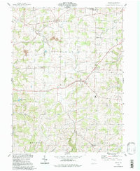
1994 Map of Berlin
USGS Topo · Published 1998About this map
Berlin serves as the central hub for this portion of Holmes County, situated at a key crossroads where the landscape transitions into the expansive The Plains to the north. The area's settlement pattern is defined by a high density of rural institutions, including numerous schoolhouses like the Hiland High Sch, Wise Sch, and Troyer Sch, alongside country churches such as Bethel Ch. These structures, combined with smaller hamlets like Charm, Bunker Hill, and Mt Hope, reflect the enduring communal character of the region's agricultural society.
Find a feature on this map
41 named features on this map. Tap any name to fly to it.
Don’t see what you’re looking for? This feature index may not catch every label — zoom into the map to look around manually.
Map Details
Editions of this 1994 Berlin Map
This is the sole edition of this map. No revisions or reprints were ever made.
Other maps of this area

1911 · Newcomerstown
USGS Topo · 1:62,500

1913 · Newcomerstown
USGS Topo · 1:62,500

1913 · Coshocton
USGS Topo · 1:62,500

1914 · Navarre
USGS Topo · 1:62,500

1915 · Millersburg
USGS Topo · 1:62,500

1915 · Coshocton
USGS Topo · 1:62,500

1943 · Millersburg
USGS Topo · 1:62,500

1943 · Coshocton
USGS Topo · 1:62,500

1943 · Newcomerstown
USGS Topo · 1:62,500

1944 · Navarre
USGS Topo · 1:62,500