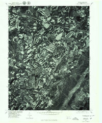
1977 Map of Berlin
USGS Topo · Published 1978About this map
Stony Creek winds through a landscape defined by intensive agricultural contouring in this late-1970s orthophotoquad of Somerset County. The town of Berlin serves as the central hub, surrounded by smaller coal and farming settlements including Macdonaldton, Roxbury, and Shaft. Produced in cooperation with the Soil Conservation Service, the aerial imagery highlights the distinct terracing and strip-cropping patterns that dominate the terrain between Brotherton and Downey. These land-use signatures provide a clear visual record of mid-century conservation practices in the Pennsylvania highlands. To the south, Goodtown and the area surrounding Shaft indicate the region's long-standing connection to local industrial activities, while the visible road networks connecting these hamlets reveal the established rural infrastructure before modern expansion.
Find a feature on this map
8 named features on this map. Tap any name to fly to it.
Don’t see what you’re looking for? This feature index may not catch every label — zoom into the map to look around manually.
Map Details
Editions of this 1977 Berlin Map
This is the sole edition of this map. No revisions or reprints were ever made.
Other maps of this area

1913 · Somerset
USGS Topo · 1:62,500

1914 · Windber
USGS Topo · 1:62,500

1915 · Somerset
USGS Topo · 1:62,500

1916 · Windber
USGS Topo · 1:62,500

1921 · Meyersdale
USGS Topo · 1:62,500

1923 · Berlin
USGS Topo · 1:48,000

1929 · Berlin
USGS Topo · 1:62,500

1939 · Meyersdale
USGS Topo · 1:62,500

1944 · Somerset
USGS Topo · 1:62,500

1944 · Windber
USGS Topo · 1:62,500
Featured Places
- Berlin, PA
- Somerset Township, PA
- Brotherton, Brothersvalley Township
- Macdonaldton, Brothersvalley Township
- Stonycreek Township, PA