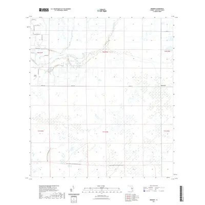
2021 Map of Bermont
USGS Topo · Published 2021About this map
Bermont sits at a junction of rural roads in this modern survey of Charlotte County, where the Florida landscape is defined by extensive wetlands and drainage systems. The northern portion of the map is marked by the winding course of Shell Cr, which is fed by tributary waters from Myrtle Slough and Cypress Slough. To the south, the terrain becomes increasingly marshy, dominated by the sprawling conservation lands of the Babcock Webb Wildlife Management Area. This area contains numerous seasonal ponds and small water bodies like Horse Leg Lake. Residential development is concentrated in the northwest corner, appearing as a grid of named streets such as Prairie Creek Blvd and River Ranch Ct, contrasting with the vast, undeveloped sections of the wildlife management area that cover the southern half of the quadrangle. Private aviation is represented by the Adana Airfield, tucked away near the western boundary.
Find a feature on this map
24 named features on this map. Tap any name to fly to it.
Don’t see what you’re looking for? This feature index may not catch every label — zoom into the map to look around manually.
Map Details
Editions of this 2021 Bermont Map
This is the sole edition of this map. No revisions or reprints were ever made.
Other maps of this area

1956 · Arcadia SE
USGS Topo · 1:24,000

1956 · Telegraph Swamp
USGS Topo · 1:24,000

1956 · Cleveland
USGS Topo · 1:24,000

1956 · Telegraph Swamp NW
USGS Topo · 1:24,000

1956 · Ft. Ogden
USGS Topo · 1:24,000

1956 · Long Island Marsh SW
USGS Topo · 1:24,000

1956 · Bermont
USGS Topo · 1:24,000

1956 · West Palm Beach
USGS Topo · 1:250,000

1956 · Fort Pierce
USGS Topo · 1:250,000

1957 · West Palm Beach
USGS Topo · 1:250,000