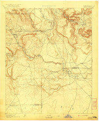
1894 Map of Bernal
USGS Topo · Published 1921About this map
The Pecos River carves a deep path through this 1890s New Mexico landscape, anchoring a string of traditional Hispanic settlements and plazas. Communities like San Miguel, La Cuesta, and Anton Chico follow the river's course, while the Atchison Topeka and Santa Fe Railroad cuts across the northern terrain, creating a separate corridor of movement through Bernal and San Miguel Station. The survey illustrates the striking transition from the wooded elevations of the Santa Fe National Forest to the expansive plateaus of Mesa Agua Segura and the depths of Canyon Blanco. This era represents a period when the iron rail and ancient river-valley agriculture coexisted as primary economic drivers. Further east, smaller outposts like La Liendre and Los Estaritos sit nestled against the drainages of Rio Tecolote and Rio Gallinas, highlighting the delicate water-dependent settlement patterns of the high desert.
Find a feature on this map
34 named features on this map. Tap any name to fly to it.
Don’t see what you’re looking for? This feature index may not catch every label — zoom into the map to look around manually.
Map Details
Editions of this 1894 Bernal Map
4 editions found

Other maps of this area

1889 · Las Vegas
USGS Topo · 1:125,000

1889 · Santa Fe
USGS Topo · 1:125,000

1890 · Bernal
USGS Topo · 1:125,000

1891 · Bernal
USGS Topo · 1:125,000

1891 · Las Vegas
USGS Topo · 1:125,000

1892 · Watrous
USGS Topo · 1:125,000

1892 · Corazon
USGS Topo · 1:125,000

1893 · Las Vegas
USGS Topo · 1:125,000

1894 · Corazon
USGS Topo · 1:125,000

1894 · Watrous
USGS Topo · 1:125,000