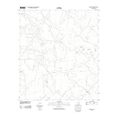
2010 Map of Bernardo
USGS Topo · Published 2010About this map
Bernardo sits at the heart of a landscape defined by the winding course of the San Bernard River and its numerous tributaries. This rural Texas terrain is characterized by a dense network of family-named roads, such as Zimmerscheidt Rd and Henneke Rd, which connect scattered homesteads and agricultural tracts. For genealogists, the map is remarkably detailed in its recording of early settler history, featuring a high concentration of private and community burial grounds including Kanstainer Cemetery, Zion Cemetery, and the Gaedecker Cemetery. Water features dominate the local geography, from the Little San Bernard River to smaller drainages like Schmitt Creek and Church Creek. The presence of the Bailey Lake Dam on Bailey Lake represents one of the few significant engineered landmarks in an area otherwise dedicated to open land and seasonal creek beds like Yellow Creek and Piney Creek.
Find a feature on this map
51 named features on this map. Tap any name to fly to it.
Don’t see what you’re looking for? This feature index may not catch every label — zoom into the map to look around manually.
Map Details
Editions of this 2010 Bernardo Map
This is the sole edition of this map. No revisions or reprints were ever made.
Other maps of this area

1919 · Fayettsville
USGS Topo · 1:62,500

1953 · Seguin
USGS Topo · 1:250,000

1956 · Bellville
USGS Topo · 1:62,500

1956 · Glidden
USGS Topo · 1:62,500

1957 · Eagle Lake
USGS Topo · 1:62,500

1957 · Columbus
USGS Topo · 1:24,000

1958 · Seguin
USGS Topo · 1:250,000

1958 · Industry
USGS Topo · 1:24,000

1958 · Frelsburg
USGS Topo · 1:24,000

1958 · Bernardo
USGS Topo · 1:24,000