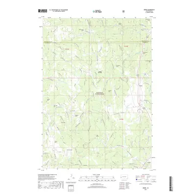
2017 Map of Berne
USGS Topo · Published 2017About this map
Black Hills National Forest land dominates this 2017 survey, where a complex network of forest roads and gulches defines the landscape northwest of Custer. The terrain is marked by numerous springs and drainages, such as Wabash Spring and Vanderlehr Creek, which have historically sustained this portion of South Dakota's timbered interior. Small settlements like Vestal Springs and Berne are located alongside major peaks like Thunderhead Mountain and Atlantic Hill. The map reveals a dense system of Forest Development Roads, including Bear Mountain Drive and Saginaw Road, which follow the natural contours of the Black Hills. These routes provide access to named landmarks with evocative local histories, such as Bugtown Gulch and Graveyard Gulch, highlighting the area's transition from early frontier settlement to its role as a managed national resource.
Find a feature on this map
97 named features on this map. Tap any name to fly to it.
Don’t see what you’re looking for? This feature index may not catch every label — zoom into the map to look around manually.
Map Details
Editions of this 2017 Berne Map
This is the sole edition of this map. No revisions or reprints were ever made.
Other maps of this area

1896 · Harney Peak
USGS Topo · 1:125,000

1901 · Harney Peak
USGS Topo · 1:125,000

1954 · Fourmile
USGS Topo · 1:24,000

1954 · Custer
USGS Topo · 1:24,000

1954 · Hill City
USGS Topo · 1:24,000

1954 · Berne
USGS Topo · 1:24,000

1955 · Jewel Cave
USGS Topo · 1:24,000

1955 · Signal Hill
USGS Topo · 1:24,000
1955 · Cicero Peak
USGS Topo · 1:24,000

1955 · Hot Springs
USGS Topo · 1:250,000