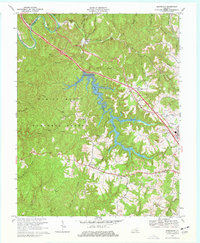
1969 Map of Bernstadt
USGS Topo · Published 1977About this map
Wood Creek Lake serves as a central feature of this Laurel County landscape, winding through the heart of the Daniel Boone National Forest. The geography is defined by the sharp transition between the upland plateaus and the deep drainages of the Rockcastle River and Wood Creek. This 1969 revision documents a rural community centered around small settlements like Bernstadt and Hare, where local life is anchored by institutions such as St Johns Ch and Colony Sch. The influence of the Louisville and Nashville railroad is evident in the north, where it follows the Little Rockcastle River valley near Hazel Patch. Industrial activity is marked by several strip mines in the eastern hills, while the County Farm in the south provides a glimpse into the era's local civic infrastructure. This map is particularly valuable for genealogists tracing family names associated with the numerous smaller cemeteries like Whitt Cem and Snuffer Cem.
Find a feature on this map
49 named features on this map. Tap any name to fly to it.
Don’t see what you’re looking for? This feature index may not catch every label — zoom into the map to look around manually.
Map Details
Editions of this 1969 Bernstadt Map
3 editions found
Other maps of this area

1893 · London
USGS Topo · 1:125,000

1897 · London
USGS Topo · 1:125,000

1952 · Lily
USGS Topo · 1:24,000

1952 · London SW
USGS Topo · 1:24,000

1952 · Billows
USGS Topo · 1:24,000

1952 · Ano
USGS Topo · 1:24,000

1952 · Bernstadt
USGS Topo · 1:24,000

1952 · London
USGS Topo · 1:24,000

1953 · Livingston
USGS Topo · 1:24,000

1953 · Mount Vernon
USGS Topo · 1:24,000