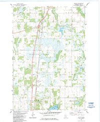
1983 Map of Beroun
USGS Topo · Published 1984About this map
Beroun serves as a central hub in this Pine County landscape, situated along the Burlington Northern railroad corridor. The area is defined by a low-lying aquatic network, where Mission Creek and Cedar Creek meander through marshy terrain toward Cross Lake and Norway Point. Cultural landmarks such as St Joseph Cem and Cech Cem provide valuable points of reference for genealogists, while smaller named locations like Stensrud and Poke mark the rural settlement patterns of the early 1980s. Numerous gravel pits scattered throughout the townships of Hinckley, Barry, and Munch point to the local importance of aggregate mining in supporting the region's infrastructure and development during this era.
Find a feature on this map
24 named features on this map. Tap any name to fly to it.
Don’t see what you’re looking for? This feature index may not catch every label — zoom into the map to look around manually.
Map Details
Editions of this 1983 Beroun Map
2 editions found
Other maps of this area

1953 · Duluth
USGS Topo · 1:250,000

1953 · Stillwater
USGS Topo · 1:250,000

1955 · Stillwater
USGS Topo · 1:250,000

1958 · Stillwater
USGS Topo · 1:250,000

1958 · Duluth
USGS Topo · 1:250,000

1961 · Sandstone
USGS Topo · 1:62,500

1961 · Brook Park
USGS Topo · 1:62,500

1961 · Pine City
USGS Topo · 1:62,500

1965 · Stillwater
USGS Topo · 1:250,000
1968 · Kroschel
USGS Topo · 1:24,000