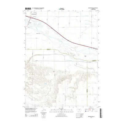
2014 Map of Bertrand NW
USGS Topo · Published 2014About this map
The Lexington municipal area anchors the northern edge of this Platte River valley landscape, where the Lexington Bridge spans the braided channels of the Platte River. This 2014 survey reveals an intricate hydraulic network essential to the region's agricultural character, including the Phelps County Canal, Beatty Ditch, and the Berquist Lateral. South of the river, the terrain transitions into complex drainage patterns near Plum Cr and Spring Cr. For those researching local history, the Robb Cem is a notable landmark situated among the section roads and hills. The map also detail's the geography of the river valley's shifting landscape, naming features like Danielson Island and Jeffreys Island, alongside water management structures such as the Phillippi Reservoir.
Find a feature on this map
43 named features on this map. Tap any name to fly to it.
Don’t see what you’re looking for? This feature index may not catch every label — zoom into the map to look around manually.
Map Details
Editions of this 2014 Bertrand NW Map
This is the sole edition of this map. No revisions or reprints were ever made.
Other maps of this area

1896 · Lexington
USGS Topo · 1:125,000

1899 · Lexington
USGS Topo · 1:125,000

1955 · Grand Island
USGS Topo · 1:250,000

1957 · Grand Island
USGS Topo · 1:250,000

1958 · Grand Island
USGS Topo · 1:250,000

1962 · Lexington West
USGS Topo · 1:24,000

1962 · Lexington SE
USGS Topo · 1:24,000

1962 · Lexington East
USGS Topo · 1:24,000
1962 · Overton
USGS Topo · 1:24,000

1962 · Bertrand NW
USGS Topo · 1:24,000