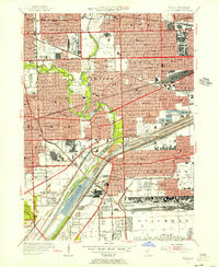
1953 Map of Berwyn
USGS Topo · Published 1956About this map
Industrial corridors and dense suburban expansion define this mid-century portrait of western Cook County. The Chicago Sanitary and Ship Canal and the Des Plaines River serve as the primary geographical anchors, flanked by the massive Clearing Industrial District and numerous limestone quarries near Mc Cook. This era shows the region as a critical transportation and healthcare hub, featuring the sprawling VA Hospital Hines and the busy Midway Airport on the edge of Chicago.
Find a feature on this map
110 named features on this map. Tap any name to fly to it.
Don’t see what you’re looking for? This feature index may not catch every label — zoom into the map to look around manually.
Map Details
Editions of this 1953 Berwyn Map
This is the sole edition of this map. No revisions or reprints were ever made.
Other maps of this area

1889 · Chicago
USGS Topo · 1:62,500

1890 · Des Plaines
USGS Topo · 1:62,500

1891 · Chicago
USGS Topo · 1:62,500

1891 · Riverside
USGS Topo · 1:62,500

1892 · Calumet
USGS Topo · 1:62,500

1893 · Calumet
USGS Topo · 1:62,500

1893 · Riverside
USGS Topo · 1:62,500

1894 · Des Plaines
USGS Topo · 1:62,500

1900 · Chicago
USGS Topo · 1:62,500

1900 · Des Plaines
USGS Topo · 1:62,500