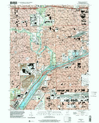
1998 Map of Berwyn
USGS Topo · Published 2002About this map
The Des Plaines River and the Chicago Sanitary and Ship Canal dominate the industrial and hydrological spine of this Cook County region, creating a stark corridor between the dense residential grids of Berwyn and Cicero. This landscape is defined by its massive institutional and infrastructure footprints, from the sprawling grounds of Resurrection Cemetery and Waldheim Cemetery to the critical healthcare complexes of Hines VA Hospital and Loyola University Medical Ctr. The map details the transition from the forested curves of the County Forest Preserve and Portage Woods to the heavy industrial zones near Summit and McCook, where a large Quarry and the Sewage Disposal works reflect the area's role in supporting Chicago's urban growth. A dense network of parochial schools, such as St Mary of Celle Sch and St Leonard Sch, highlights the established community fabric of these historic inner-ring suburbs.
Find a feature on this map
83 named features on this map. Tap any name to fly to it.
Don’t see what you’re looking for? This feature index may not catch every label — zoom into the map to look around manually.
Map Details
Editions of this 1998 Berwyn Map
This is the sole edition of this map. No revisions or reprints were ever made.
Other maps of this area

1889 · Chicago
USGS Topo · 1:62,500

1890 · Des Plaines
USGS Topo · 1:62,500

1891 · Chicago
USGS Topo · 1:62,500

1891 · Riverside
USGS Topo · 1:62,500

1892 · Calumet
USGS Topo · 1:62,500

1893 · Calumet
USGS Topo · 1:62,500

1893 · Riverside
USGS Topo · 1:62,500

1894 · Des Plaines
USGS Topo · 1:62,500

1900 · Chicago
USGS Topo · 1:62,500

1900 · Des Plaines
USGS Topo · 1:62,500