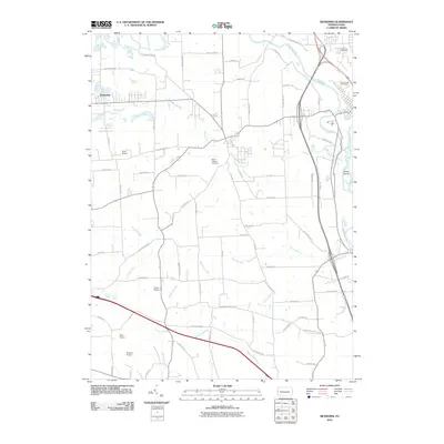
2010 Map of Bessemer
USGS Topo · Published 2010About this map
Bessemer and its surrounding Lawrence County landscape are defined by a network of rural roads and vital waterways. The Mahoning River and Shenango River flow through the eastern portion of the quadrangle, with Shaw Island situated within the current. Small tributaries such as Sugar Creek, Edwards Run, and Jenkins Run drain the rolling terrain. The area's infrastructure is marked by several small airfields, including Gwin Airport, Evans Airport, Reno Airport, and Kimmel Airport, suggesting a significant regional aviation presence. Genealogists will find interest in the documented burial sites, specifically Madonna Cemetery, Valley View Cemetery, and Mount Jackson Cemetery. Local history is further preserved in the names of thoroughfares like Smalls Ferry Rd and Mohawk School Rd, which reflect the historic connectivity of these Pennsylvania communities.
Find a feature on this map
66 named features on this map. Tap any name to fly to it.
Don’t see what you’re looking for? This feature index may not catch every label — zoom into the map to look around manually.
Map Details
Editions of this 2010 Bessemer Map
This is the sole edition of this map. No revisions or reprints were ever made.
Other maps of this area

1902 · New Castle
USGS Topo · 1:62,500

1904 · Newcastle
USGS Topo · 1:62,500

1905 · Neshannock
USGS Topo · 1:62,500

1906 · Youngstown
USGS Topo · 1:62,500

1907 · Neshannock
USGS Topo · 1:62,500

1907 · Columbiana
USGS Topo · 1:62,500

1908 · Youngstown
USGS Topo · 1:62,500

1909 · Columbiana
USGS Topo · 1:62,500

1950 · Cleveland
USGS Topo · 1:250,000

1951 · Canton
USGS Topo · 1:250,000