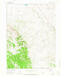
1963 Map of Best Ranch
USGS Topo · Published 1965About this map
The Union Pacific railroad corridor and the historic path of the Overland Trail dominate this 1963 survey of Albany County, Wyoming. This high-plains landscape near Tie Siding is characterized by its legacy of early western transit, where heavy rail and wagon routes converged against the foothills of Boulder Ridge. The map documents a network of private holdings including Weaver Ranch, Higgins Ranch, and Wright Ranch, illustrating the region's enduring ranching economy during the mid-20th century.
Find a feature on this map
25 named features on this map. Tap any name to fly to it.
Don’t see what you’re looking for? This feature index may not catch every label — zoom into the map to look around manually.
Map Details
Editions of this 1963 Best Ranch Map
3 editions found
Other maps of this area

1895 · Laramie
USGS Topo · 1:125,000

1902 · Laramie
USGS Topo · 1:125,000

1905 · Sherman
USGS Topo · 1:125,000

1905 · Laramie
USGS Topo · 1:125,000

1906 · Laramie
USGS Topo · 1:125,000

1907 · Livermore
USGS Topo · 1:125,000

1908 · Laramie
USGS Topo · 1:125,000

1909 · Livermore
USGS Topo · 1:125,000

1916 · Home
USGS Topo · 1:125,000

1920 · Home
USGS Topo · 1:125,000