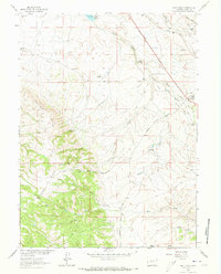
1963 Map of Best Ranch
USGS Topo · Published 1973About this map
Best Ranch and several other family-named cattle operations define this high-plateau landscape along the Albany and Laramie county line. The map captures the logistical heart of the region where the Union Pacific railroad corridor meets historical migration routes. The Overland Trail and Overland Road traverse the eastern portion of the sheet, tracing the path of nineteenth-century western travel through the wind-swept plains near Tie Siding. To the west, the topography rises sharply toward Boulder Ridge, where the dense timber of the Medicine Bow National Forest begins. Water management is a central theme, evidenced by the Willow Creek Reservoir and its Spillway, which supports the ranching economy by capturing drainage from Willow Creek and Fish Creek. This survey provides a clear view of the transition from open grazing land to the forested uplands of southern Wyoming.
Find a feature on this map
31 named features on this map. Tap any name to fly to it.
Don’t see what you’re looking for? This feature index may not catch every label — zoom into the map to look around manually.
Map Details
Editions of this 1963 Best Ranch Map
3 editions found
Other maps of this area

1895 · Laramie
USGS Topo · 1:125,000

1902 · Laramie
USGS Topo · 1:125,000

1905 · Sherman
USGS Topo · 1:125,000

1905 · Laramie
USGS Topo · 1:125,000

1906 · Laramie
USGS Topo · 1:125,000

1907 · Livermore
USGS Topo · 1:125,000

1908 · Laramie
USGS Topo · 1:125,000

1909 · Livermore
USGS Topo · 1:125,000

1916 · Home
USGS Topo · 1:125,000

1920 · Home
USGS Topo · 1:125,000