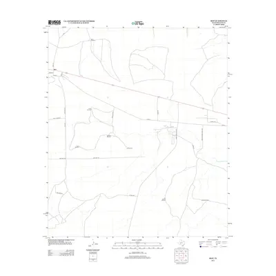
2012 Map of Best
USGS Topo · Published 2012About this map
The settlement of Best anchors this West Texas landscape, positioned along the historical alignment of Texon Rd and Co Rd-22. This Reagan County survey illustrates an arid environment defined by its water infrastructure, where numerous scattered windmills serve as primary landmarks across the desert terrain. Named sites like Sand Windmill, Twin Tank Windmill, and Six Section Windmill underscore the necessity of groundwater for ranching and industry in this region. The map also reveals the industrial footprint of the area, featuring Oil Well Windmill and the expansive reach of Farm-to-Market Road 1676. At the eastern edge, the basin of Big Lake provides a natural geographical terminus for the local road network, which includes routes such as Lone Wolf Rd and Golf Course Rd.
Find a feature on this map
22 named features on this map. Tap any name to fly to it.
Don’t see what you’re looking for? This feature index may not catch every label — zoom into the map to look around manually.
Map Details
Editions of this 2012 Best Map
This is the sole edition of this map. No revisions or reprints were ever made.
Other maps of this area

1920 · Big Lake
USGS Topo · 1:62,500

1922 · Big Lake
USGS Topo · 1:62,500

1928 · Rankin
USGS Topo · 1:125,000

1954 · San Angelo
USGS Topo · 1:250,000

1958 · San Angelo
USGS Topo · 1:250,000

1965 · San Angelo
USGS Topo · 1:250,000
1970 · Texon SE
USGS Topo · 1:24,000

1970 · Garrison Draw
USGS Topo · 1:24,000

1970 · Gardener Draw
USGS Topo · 1:24,000
1970 · Divide Draw
USGS Topo · 1:24,000