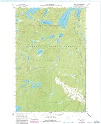
1960 Map of Beth Lake
USGS Topo · Published 1986About this map
Boundary Waters Canoe Area Wilderness and the Superior National Forest define this landscape of interconnected lakes and glacial drainages in Cook County. The map details the transition between these protected lands, centered on the chain of water bodies including Beth Lake and the massive Alton Lake. A subtle shift in human activity is evident on the eastern edge, where Sawbill Road provides access to the Sawbill Guard Station and the Sawbill Lake Campground at the edge of the primitive wilderness. From the headwaters of the Temperance River to the various smaller basins like Maggie Lake and Sunhigh Lake, the terrain reflects a world where transportation is dictated by water and portage rather than pavement. The township boundaries of Schroeder and the presence of State Forest Boundaries delineate the administrative management of this northern Minnesota interior during the mid-to-late twentieth century.
Find a feature on this map
34 named features on this map. Tap any name to fly to it.
Don’t see what you’re looking for? This feature index may not catch every label — zoom into the map to look around manually.
Map Details
Editions of this 1960 Beth Lake Map
3 editions found
Other maps of this area

1954 · Two Harbors
USGS Topo · 1:250,000

1955 · Tofte
USGS Topo · 1:62,500

1955 · Cramer
USGS Topo · 1:62,500

1957 · Two Harbors
USGS Topo · 1:250,000

1958 · Two Harbors
USGS Topo · 1:250,000

1960 · Lake Polly
USGS Topo · 1:24,000

1960 · Kawishiwi Lake
USGS Topo · 1:24,000

1960 · Sawbill Camp
USGS Topo · 1:24,000

1960 · Beth Lake
USGS Topo · 1:24,000
1960 · Cherokee Lake
USGS Topo · 1:24,000