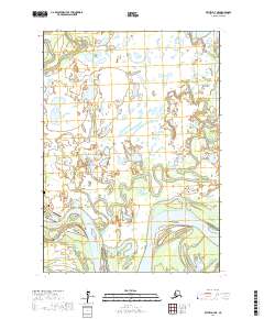
2017 Map of Bethel D-7 NE
USGS Topo · Published 2017About this map
Akiachak is the focal point of this survey, situated on the north bank of the Kuskokwim River in the Yukon-Kuskokwim Delta. The map reveals the intricate water-and-land relationship of this riverine environment, where the braided channels of the Kuskokwim separate large landmasses like Kiktak Island from the mainland. The village layout is modest, centered around Main Street, with the Akiachak Airport serving as a vital connection point to the larger region. To the northwest, the Akiachak Historic Cem provides a point of genealogical and historical interest. Beyond the settlement, the landscape is defined by the Gweek River and a dense network of unnamed lakes and ponds, illustrating the complex hydrology of the Alaskan interior before modern development shifted the natural course of these waterways.
Find a feature on this map
13 named features on this map. Tap any name to fly to it.
Don’t see what you’re looking for? This feature index may not catch every label — zoom into the map to look around manually.
Map Details
Editions of this 2017 Bethel D-7 NE Map
This is the sole edition of this map. No revisions or reprints were ever made.
Other maps of this area

1947 · Russian Mission
USGS Topo · 1:250,000

1950 · Russian Mission
USGS Topo · 1:250,000

1950 · Bethel
USGS Topo · 1:250,000

1954 · Russian Mission A-6
USGS Topo · 1:63,360
1954 · Russian Mission A-7
USGS Topo · 1:63,360

1954 · Bethel D-7
USGS Topo · 1:63,360

1954 · Bethel D-6
USGS Topo · 1:63,360

1980 · Russian Mission
USGS Topo · 1:250,000

1980 · Bethel
USGS Topo · 1:250,000
2017 · Bethel D-6 SW
USGS Topo · 1:25,000