
1954 Map of Bethel D-6
USGS Topo · Published 1965About this map
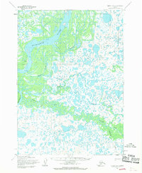
Akiak stands as the primary settlement on this mid-century survey, situated along the bank of the massive Kuskokwim River. The landscape is dominated by a complex network of waterways, where the river braids into numerous channels and is flanked by expansive Tidal Flats. This intricate hydrologic system includes major tributaries such as the Kisaralik River and Kasigluk River, which meander through a low-lying terrain characterized by countless small ponds and wetlands.
Find a feature on this map
11 named features on this map. Tap any name to fly to it.
Don’t see what you’re looking for? This feature index may not catch every label — zoom into the map to look around manually.
Map Details
Editions of this 1954 Bethel D-6 Map
2 editions found
Other maps of this area

1947 · Russian Mission
USGS Topo · 1:250,000

1950 · Russian Mission
USGS Topo · 1:250,000

1950 · Bethel
USGS Topo · 1:250,000

1954 · Russian Mission A-6
USGS Topo · 1:63,360

1954 · Russian Mission A-5
USGS Topo · 1:63,360
1954 · Russian Mission A-7
USGS Topo · 1:63,360

1954 · Bethel C-6
USGS Topo · 1:63,360

1954 · Bethel C-5
USGS Topo · 1:63,360

1954 · Bethel D-7
USGS Topo · 1:63,360
1954 · Bethel C-7
USGS Topo · 1:63,360