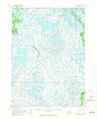
1954 Map of Bethel C-7
USGS Topo · Published 1965About this map
The Kwethuk River dominates the eastern edge of this 1954 landscape, winding through a complex system of water bodies and wetlands within the Seward Meridian. This area is defined by a dense concentration of unnamed lakes and marshy terrain, illustrated through detailed topography based on aerial photography from the early 1950s. The Kuskok River joins the system in the northeast corner, contributing to a hydrological network typical of the Alaska delta regions. While no permanent human settlements or roads are recorded on this sheet, the map serves as a primary record of the natural drainage patterns and the intricate mosaic of water and land prior to more contemporary developments. It captures a specific moment when the Bureau of Land Management was predetermining land lines for unsurveyed locations across these remote folios.
Find a feature on this map
2 named features on this map. Tap any name to fly to it.
Don’t see what you’re looking for? This feature index may not catch every label — zoom into the map to look around manually.
Map Details
Editions of this 1954 Bethel C-7 Map
2 editions found
Other maps of this area

1950 · Bethel
USGS Topo · 1:250,000

1954 · Bethel D-8
USGS Topo · 1:63,360

1954 · Bethel B-6
USGS Topo · 1:63,360

1954 · Bethel C-6
USGS Topo · 1:63,360

1954 · Bethel D-7
USGS Topo · 1:63,360

1954 · Bethel B-7
USGS Topo · 1:63,360

1954 · Bethel D-6
USGS Topo · 1:63,360

1954 · Bethel B-8
USGS Topo · 1:63,360

1954 · Bethel C-8
USGS Topo · 1:63,360

1980 · Bethel
USGS Topo · 1:250,000