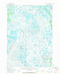
1954 Map of Bethel C-7
USGS Topo · Published 1971About this map
Kwethluk River winds through the northeastern corner of this tundra landscape, which is defined by an intricate network of thousands of small lakes and ponds. Based on aerial photography from 1952 and 1957, this topographical study reveals a region where water and land are nearly indistinguishable, reflecting the complex drainage patterns of the Yukon-Kuskokwim Delta. While the majority of the area remains an unnamed expanse of wetlands, the Kuskokwak River appears as a secondary watercourse in the far northeast. The map provides a precise record of the lake-strewn terrain in the mid-1950s, documenting a wilderness where no roads or trails existed, emphasizing the extreme isolation and the dominance of natural hydrological processes over human development during this era.
Find a feature on this map
2 named features on this map. Tap any name to fly to it.
Don’t see what you’re looking for? This feature index may not catch every label — zoom into the map to look around manually.
Map Details
Editions of this 1954 Bethel C-7 Map
2 editions found
Other maps of this area

1950 · Bethel
USGS Topo · 1:250,000

1954 · Bethel D-8
USGS Topo · 1:63,360

1954 · Bethel B-6
USGS Topo · 1:63,360

1954 · Bethel C-6
USGS Topo · 1:63,360

1954 · Bethel D-7
USGS Topo · 1:63,360

1954 · Bethel B-7
USGS Topo · 1:63,360

1954 · Bethel D-6
USGS Topo · 1:63,360

1954 · Bethel B-8
USGS Topo · 1:63,360

1954 · Bethel C-8
USGS Topo · 1:63,360
1954 · Bethel C-7
USGS Topo · 1:63,360