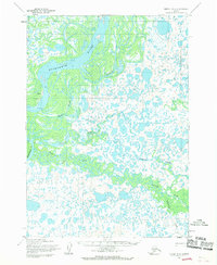
1954 Map of Bethel D-6
USGS Topo · Published 1970About this map
Akiak sits on the western bank of the Kuskokwim River, serving as a primary focal point in this water-defined landscape. The terrain is a complex network of wetlands and shifting channels, characterized by the winding Mishevik Slough and Reindeer Slough. Numerous Tidal Flats emphasize the influence of the sea on this river system, while the presence of a Landing Strip near the settlement highlights the importance of aviation in navigating this roadless region. To the south and east, the Kisaralik River and Kasigluk River converge through an intricate delta of smaller streams like Columbia Creek. This 1950s-era survey by the Army Map Service captures the natural drainage patterns and the isolated position of riverine settlements before later modernization, documenting a landscape where water travel and bush flying were the essential links to the outside world.
Find a feature on this map
13 named features on this map. Tap any name to fly to it.
Don’t see what you’re looking for? This feature index may not catch every label — zoom into the map to look around manually.
Map Details
Editions of this 1954 Bethel D-6 Map
2 editions found
Other maps of this area

1947 · Russian Mission
USGS Topo · 1:250,000

1950 · Russian Mission
USGS Topo · 1:250,000

1950 · Bethel
USGS Topo · 1:250,000

1954 · Russian Mission A-6
USGS Topo · 1:63,360

1954 · Russian Mission A-5
USGS Topo · 1:63,360
1954 · Russian Mission A-7
USGS Topo · 1:63,360

1954 · Bethel C-6
USGS Topo · 1:63,360

1954 · Bethel C-5
USGS Topo · 1:63,360

1954 · Bethel D-7
USGS Topo · 1:63,360

1954 · Bethel D-6
USGS Topo · 1:63,360