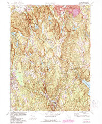
1970 Map of Bethel
USGS Topo · Published 1988About this map
Saugatuck Reservoir anchors the southeastern landscape of this Fairfield County terrain, where the Saugatuck River and Norwalk River drainage basins meet. The map reveals a transition from the established borough of Bethel and the southern edge of Danbury toward the smaller villages of Redding, Branchville, and Georgetown. This era captures the region's mid-century character, balancing its suburban growth near Danbury Municipal Airport with large tracts of protected land like Wooster Mountain State Park and Putnam Memorial State Park. The Conrail rail line tracks through the center of the sheet, connecting industrial points and small depots such as West Redding. For those tracing local heritage, the map identifies numerous schools and spiritual centers, including St Andrews Ch and the Umpawaug Cemetery, nestled among named peaks like Moses Mtn and Topstone Mtn.
Find a feature on this map
83 named features on this map. Tap any name to fly to it.
Don’t see what you’re looking for? This feature index may not catch every label — zoom into the map to look around manually.
Map Details
Editions of this 1970 Bethel Map
3 editions found
Other maps of this area

1892 · Stamford
USGS Topo · 1:62,500

1892 · Danbury
USGS Topo · 1:62,500

1892 · Norwalk
USGS Topo · 1:62,500

1892 · Carmel
USGS Topo · 1:62,500

1893 · Carmel
USGS Topo · 1:62,500

1893 · Stamford
USGS Topo · 1:62,500

1893 · Norwalk
USGS Topo · 1:62,500

1894 · Carmel
USGS Topo · 1:62,500

1899 · Stamford
USGS Topo · 1:62,500

1915 · Danbury
USGS Topo · 1:62,500