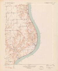
1948 Map of Bethlehem
USGS Topo · Published 1948About this map
Ohio River frontage dominates this 1938 survey of the Indiana-Kentucky borderlands, where the river carves a sharp eastward bend. The settlement of Bethlehem sits directly on the banks at the mouth of Middle Cr, serving as a central point for the surrounding rural townships. Inland, the landscape is defined by deep drainage patterns like Doolittle Hollow and Dodson Hollow, which channel water from the uplands toward the river.
Find a feature on this map
29 named features on this map. Tap any name to fly to it.
Don’t see what you’re looking for? This feature index may not catch every label — zoom into the map to look around manually.
Map Details
Editions of this 1948 Bethlehem Map
2 editions found
Other maps of this area

1905 · Prospect
USGS Topo · 1:62,500

1912 · Prospect
USGS Topo · 1:62,500

1932 · La Grange
USGS Topo · 1:62,500

1938 · Owen
USGS Topo · 1:24,000

1939 · Bethlehem
USGS Topo · 1:24,000

1939 · Madison West
USGS Topo · 1:24,000

1948 · Bethlehem
USGS Topo · 1:24,000

1948 · Madison West
USGS Topo · 1:24,000

1948 · Owen
USGS Topo · 1:24,000

1953 · Madison West
USGS Topo · 1:24,000