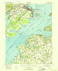
1951 Map of Betterton
USGS Topo · Published 1951About this map
Aberdeen Proving Grounds dominates the western shoreline of the northern Chesapeake Bay, illustrating the massive military footprint established in Harford County by the mid-20th century. The land is marked by artillery and tactical zones such as the Rifle Range and Pistol Range, which contrast with the adjacent Susquehanna National Wildlife Refuge. Across the water in Kent County, the landscape remains deeply agricultural and maritime, centered on the resort town of Betterton at the mouth of the Sassafras River. Inside the Stillpond Neck and Fairlee Neck peninsulas, the map documents a network of rural hamlets like Lynch, Coleman, and Hanesville, supported by the Pennsylvania RR. Local landmarks such as the Harford Furnace School and the Wildlife Banding Station reflect the area's long-standing intersection of educational, industrial, and conservationist interests during this post-war era.
Find a feature on this map
105 named features on this map. Tap any name to fly to it.
Don’t see what you’re looking for? This feature index may not catch every label — zoom into the map to look around manually.
Map Details
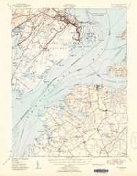
Editions of this 1951 Betterton Map
2 editions found
Other maps of this area

1893 · North Point
USGS Topo · 1:62,500

1893 · Gunpowder
USGS Topo · 1:62,500

1898 · Elkton
USGS Topo · 1:62,500

1898 · Tolchester
USGS Topo · 1:125,000

1899 · Dover
USGS Topo · 1:125,000

1900 · Elkton
USGS Topo · 1:62,500

1900 · Cecilton
USGS Topo · 1:62,500

1900 · Havre De Grace
USGS Topo · 1:62,500

1900 · Betterton
USGS Topo · 1:62,500

1901 · Belair
USGS Topo · 1:62,500