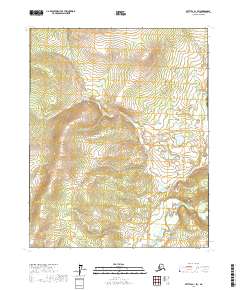
2017 Map of Bettles A-1 SW
USGS Topo · Published 2017About this map
Ray River winds through this expanse of the Yukon-Koyukuk Census Area, defining the drainage patterns of a landscape marked by complex wetland systems and rising elevations. The terrain is characterized by the transition between low-lying riparian zones and the surrounding uplands, with the river acting as the primary geographical focal point for the region. Surveyed by the U.S. Geological Survey, the map provides a look at the township and range divisions of t15n r14w, t15n r13w, t14n r14w, and t14n r13w. This 2017 edition reflects a modern era of mapping that utilizes satellite imagery and high-resolution elevation data to document the remote interior of Alaska. The lack of built infrastructure or named settlements emphasizes the wild character of the territory, where the watercourse of the river remains the most significant landmark for navigation and environmental study.
Find a feature on this map
5 named features on this map. Tap any name to fly to it.
Don’t see what you’re looking for? This feature index may not catch every label — zoom into the map to look around manually.
Map Details
Editions of this 2017 Bettles A-1 SW Map
This is the sole edition of this map. No revisions or reprints were ever made.
Other maps of this area

1951 · Bettles
USGS Topo · 1:250,000

1951 · Tanana
USGS Topo · 1:250,000

1956 · Bettles
USGS Topo · 1:250,000

1956 · Tanana D-2
USGS Topo · 1:63,360

1956 · Tanana D-1
USGS Topo · 1:63,360

1956 · Tanana
USGS Topo · 1:250,000

1960 · Tanana
USGS Topo · 1:250,000
1970 · Bettles A-1
USGS Topo · 1:63,360
1970 · Bettles A-2
USGS Topo · 1:63,360
2017 · Tanana D-1 NE
USGS Topo · 1:25,000