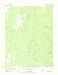
1970 Map of Bettles A-1
USGS Topo · Published 1973About this map
Fort Hamlin Hills dominate the eastern landscape of this remote interior Alaska quadrant, providing a stark topographical backdrop to the winding Ray River in the south. The terrain is largely defined by its isolation, marked by a solitary Cabin and the presence of a Winter Trail that cuts across the northern and southern sectors. This trail system indicates a landscape navigated by seasonal travel rather than permanent infrastructure, typical of the Yukon-Koyukuk region during the early 1970s. The river's serpentine path through the lowlands contrasts with the elevated ridges of the hills, illustrating a wilderness environment where movement was dictated by water and seasonal paths.
Find a feature on this map
4 named features on this map. Tap any name to fly to it.
Don’t see what you’re looking for? This feature index may not catch every label — zoom into the map to look around manually.
Map Details
Editions of this 1970 Bettles A-1 Map
2 editions found
Other maps of this area

1945 · Livengood
USGS Topo · 1:250,000

1951 · Bettles
USGS Topo · 1:250,000

1951 · Tanana
USGS Topo · 1:250,000

1951 · Livengood
USGS Topo · 1:250,000

1951 · Beaver
USGS Topo · 1:250,000

1956 · Bettles
USGS Topo · 1:250,000

1956 · Beaver
USGS Topo · 1:250,000

1956 · Livengood D-6
USGS Topo · 1:63,360

1956 · Tanana D-2
USGS Topo · 1:63,360

1956 · Tanana D-1
USGS Topo · 1:63,360