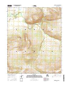
2016 Map of Bettles A-3 NE
USGS Topo · Published 2016About this map
The Kanuti River winds through this subarctic interior landscape, carving a meandering path across the northern reaches of the Yukon-Koyukuk region. In the southern portion of the sheet, the terrain rises significantly from the river basin toward the uplands surrounding Tokusatatquaten Lake. The 2016 topography illustrates the complex drainage patterns of the Alaskan wilderness, where the river's shifting course is evidenced by the numerous oxbows and marshy lowlands that define the basin. This area remains largely defined by its natural hydrology and the Public Land Survey System divisions of t16n r17w and t15n r17w, showing a landscape untouched by major road networks or permanent settlements at the time of this survey.
Find a feature on this map
6 named features on this map. Tap any name to fly to it.
Don’t see what you’re looking for? This feature index may not catch every label — zoom into the map to look around manually.
Map Details
Editions of this 2016 Bettles A-3 NE Map
This is the sole edition of this map. No revisions or reprints were ever made.
Other maps of this area

1951 · Bettles
USGS Topo · 1:250,000

1956 · Bettles
USGS Topo · 1:250,000
1970 · Bettles A-3
USGS Topo · 1:63,360

1970 · Bettles B-2
USGS Topo · 1:63,360
1970 · Bettles B-3
USGS Topo · 1:63,360
1970 · Bettles A-2
USGS Topo · 1:63,360
2016 · Bettles B-3 SW
USGS Topo · 1:25,000
2016 · Bettles A-3 SE
USGS Topo · 1:25,000
2016 · Bettles A-3 SW
USGS Topo · 1:25,000
2016 · Bettles A-3 NW
USGS Topo · 1:25,000