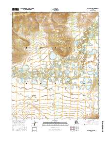
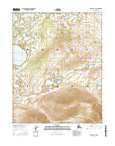
2016 Map of Bettles A-4 NE
USGS Topo · Published 2016About this map
The Kanuti River winds through this subarctic interior landscape, creating a complex network of wetlands and oxbow lakes in the central Yukon-Koyukuk region. In the heart of this terrain lies Taiholman Lake, a prominent water body situated north of the river's main meandering course. The hydrological patterns here reveal a landscape defined by seasonal water movement, where the Kanuti Lake area further downstream demonstrates the shifting nature of northern river systems. Large topographic rises flank the river valley to the north and south, providing a stark contrast between the low-lying basin and the surrounding uplands. This 2016 survey documents the intricate relationship between the river and its numerous unnamed feeder streams and ponds, which are characteristic of the Interior Alaska wilderness.
Find a feature on this map
7 named features on this map. Tap any name to fly to it.
Don’t see what you’re looking for? This feature index may not catch every label — zoom into the map to look around manually.
Map Details
Editions of this 2016 Bettles A-4 NE Map
This is the sole edition of this map. No revisions or reprints were ever made.
Other maps of this area

1951 · Bettles
USGS Topo · 1:250,000

1956 · Bettles
USGS Topo · 1:250,000
1970 · Bettles B-4
USGS Topo · 1:63,360
1970 · Bettles A-3
USGS Topo · 1:63,360
1970 · Bettles A-4
USGS Topo · 1:63,360
1970 · Bettles B-3
USGS Topo · 1:63,360
2016 · Bettles B-3 SW
USGS Topo · 1:25,000
2016 · Bettles B-4 SE
USGS Topo · 1:25,000
2016 · Bettles A-3 SW
USGS Topo · 1:25,000
2016 · Bettles B-4 SW
USGS Topo · 1:25,000