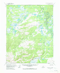
1970 Map of Bettles A-5
USGS Topo · Published 1973About this map
The Kanuti River winds in complex oxbows and meanders across the eastern portion of this wilderness landscape, defining a region of dense water networks and marshland. This 1970 aerial survey, based on photogrammetric methods, illustrates the interior Alaskian terrain within the Kanuti Flats, where the relief is characterized by hundreds of small lakes and ponds. Tributaries such as Nolitna Creek and Kadoshin Creek drain the higher elevations to the south and west, feeding into the low-lying basin. The map reflects a moment in time before significant infrastructure reached this part of the Yukon-Koyukuk region, showing land lines that remained unsurveyed and unmarked at the time of publication. For those studying the hydrology of the Koyukuk watershed, the intricate course of Holonada Creek and the surrounding wetland clusters provide a detailed record of the natural drainage patterns during the early 1970s.
Find a feature on this map
6 named features on this map. Tap any name to fly to it.
Don’t see what you’re looking for? This feature index may not catch every label — zoom into the map to look around manually.
Map Details
Editions of this 1970 Bettles A-5 Map
This is the sole edition of this map. No revisions or reprints were ever made.
Other maps of this area

1951 · Bettles
USGS Topo · 1:250,000

1951 · Tanana
USGS Topo · 1:250,000

1956 · Bettles
USGS Topo · 1:250,000

1956 · Tanana D-4
USGS Topo · 1:63,360

1956 · Tanana D-6
USGS Topo · 1:63,360
1956 · Tanana D-5
USGS Topo · 1:63,360

1956 · Tanana
USGS Topo · 1:250,000

1960 · Tanana
USGS Topo · 1:250,000
1970 · Bettles B-4
USGS Topo · 1:63,360
1970 · Bettles A-4
USGS Topo · 1:63,360