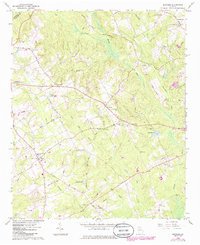
1964 Map of Between
USGS Topo · Published 1985About this map
The community of Between sits at the center of this Georgia landscape, situated at a road junction between the larger regional hubs. By the mid-1960s, the area retained its rural character, defined by a network of small settlements like Split Silk and Youth, along with numerous family-named cemeteries and country churches. The terrain is deeply carved by the Alcovy River and its tributaries, including Little Flat Creek and Beaverdam Creek. Local social life and genealogy are anchored by landmarks such as the West Walton Sch and several houses of worship, including New Hope Ch and Sardis Ch. The presence of pipelines and a Metering Station in the southern portion suggests the gradual introduction of modern utility infrastructure into these traditional agricultural lands. Many small family burial grounds, such as Jones Cem and Tucker Cem, are documented here, offering vital clues for those tracing local family roots across Walton County.
Find a feature on this map
51 named features on this map. Tap any name to fly to it.
Don’t see what you’re looking for? This feature index may not catch every label — zoom into the map to look around manually.
Map Details
Editions of this 1964 Between Map
2 editions found
Other maps of this area

1896 · Monroe
USGS Topo · 1:125,000

1953 · Athens
USGS Topo · 1:250,000

1958 · Athens
USGS Topo · 1:250,000

1959 · Athens
USGS Topo · 1:250,000

1963 · Athens
USGS Topo · 1:250,000

1964 · Bold Springs
USGS Topo · 1:24,000
1964 · Loganville
USGS Topo · 1:24,000

1964 · Between
USGS Topo · 1:24,000

1964 · Monroe
USGS Topo · 1:24,000

1964 · Winder South
USGS Topo · 1:24,000