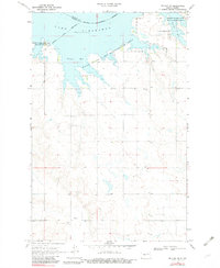
1969 Map of Beulah NE
USGS Topo · Published 1982About this map
Lake Sakakawea dominates this landscape on the Mercer and McLean county line, where the impounded waters of the Missouri River have filled the deep coulees and draws of the plains. This 1969 survey captures the reservoir at its normal pool elevation of 1838 feet, showing the intricate shoreline that formed Renner Bay and Beulah Bay. The map is particularly valuable for genealogists, as it identifies several rural burial sites that predate the reservoir's full expansion, including Kronthal Cem, Koehler Cem, and Peace Cem. Large tracts of the northern shoreline are designated as the Hille State Game Management Area and the Beaver Creek State Game Management Area, indicating a landscape transitioning from traditional agriculture toward conservation and recreation. Scattered Gravel Pits and an Indian Reservation Boundary near the water provide additional markers of the region's land use and complex jurisdictional history.
Find a feature on this map
14 named features on this map. Tap any name to fly to it.
Don’t see what you’re looking for? This feature index may not catch every label — zoom into the map to look around manually.
Map Details
Editions of this 1969 Beulah NE Map
2 editions found
Other maps of this area

1954 · McClusky
USGS Topo · 1:250,000

1958 · McClusky
USGS Topo · 1:250,000

1967 · Blackwater Lake SE
USGS Topo · 1:24,000

1967 · Blackwater Lake SW
USGS Topo · 1:24,000

1967 · Emmet SW
USGS Topo · 1:24,000

1968 · Beulah
USGS Topo · 1:24,000

1968 · Hazen West
USGS Topo · 1:24,000

1969 · Beulah NE
USGS Topo · 1:24,000
1969 · Hazen NW
USGS Topo · 1:24,000
1969 · Beulah NW
USGS Topo · 1:24,000