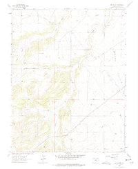
1963 Map of Beulah NE
USGS Topo · Published 1975About this map
The Minnequa Canal and the Arkansas Valley Conduit carve through the arid terrain of western Pueblo County, illustrating the critical role of water infrastructure in the development of the region. This 1963 field-checked survey reveals a landscape of high plains and deep drainage channels where water management dictates the pattern of human activity. The northeastern portion is dominated by the broad expanse of Boggs Flat, while to the south, the terrain rises toward Rock Creek Hill.
Find a feature on this map
15 named features on this map. Tap any name to fly to it.
Don’t see what you’re looking for? This feature index may not catch every label — zoom into the map to look around manually.
Map Details
Editions of this 1963 Beulah NE Map
Other maps of this area

1891 · Pueblo
USGS Topo · 1:125,000

1894 · Pueblo
USGS Topo · 1:125,000

1896 · Pueblo
USGS Topo · 1:125,000

1897 · Pueblo
USGS Topo · 1:125,000

1954 · Pueblo
USGS Topo · 1:250,000

1957 · Pueblo
USGS Topo · 1:250,000

1958 · Pueblo
USGS Topo · 1:250,000

1961 · Northwest Pueblo
USGS Topo · 1:24,000

1961 · Southwest Pueblo
USGS Topo · 1:24,000

1962 · Pueblo
USGS Topo · 1:250,000