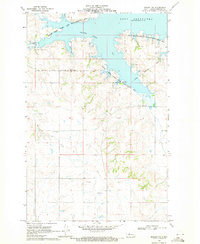
1969 Map of Beulah NW
USGS Topo · Published 1971About this map
Lake Sakakawea dominates the northern landscape of this Mercer County region, its winding shoreline and Beaver Creek Bay defining the topography of the late 1960s. The map illustrates a transitional environment where the expansive water of the reservoir meets the rugged Missouri River breaks. Cultural history is anchored by the Fort Berthold Indian Reservation Boundary and small rural sites like St Johannes Cem and Neusatz Cem, which reflect the early settlement patterns of the area. Significant portions of the land are dedicated to conservation, notably the Beaver Creek State Game Management Area. The interior terrain is marked by intermittent drainages like Beaver Creek and occasional industrial activity represented by several Gravel Pits, showcasing the balance between public land management and local resource extraction.
Find a feature on this map
12 named features on this map. Tap any name to fly to it.
Don’t see what you’re looking for? This feature index may not catch every label — zoom into the map to look around manually.
Map Details
Editions of this 1969 Beulah NW Map
2 editions found
Other maps of this area

1953 · Watford City
USGS Topo · 1:250,000

1954 · McClusky
USGS Topo · 1:250,000

1957 · Watford City
USGS Topo · 1:250,000

1958 · McClusky
USGS Topo · 1:250,000

1967 · Watford City
USGS Topo · 1:250,000

1967 · Blackwater Lake SE
USGS Topo · 1:24,000

1967 · Raub SE
USGS Topo · 1:24,000

1967 · Blackwater Lake SW
USGS Topo · 1:24,000

1968 · Beulah
USGS Topo · 1:24,000

1969 · Beulah NE
USGS Topo · 1:24,000