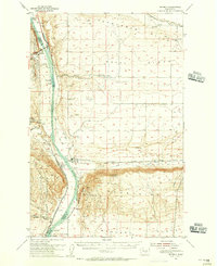
1954 Map of Beverly
USGS Topo · Published 1956About this map
The Columbia River carves a deep path through Central Washington's basalt landscape in this mid-century survey, revealing a region defined by its geology and its transit corridors. On the western bank, the Ginko Petrified Forest State Park and Indian Petroglyphs point to ancient history, while the Yakima Firing Center Military Reservation occupies the heights of the south. The railroad era is in full view along the eastern shore, where the Chicago Milwaukee St Paul and Pacific line connects small outposts like Beverly, Beverly Junction, and Jericho. North of the massive Sentinel Mtn and its steep Sentinel Bluffs, the landscape opens into the wide Royal Slope and Wahluke Slope. These arid reaches, marked by Crab Creek and the Frenchman Hills, show early evidence of irrigation and agricultural expansion through a developing Canal network.
Find a feature on this map
44 named features on this map. Tap any name to fly to it.
Don’t see what you’re looking for? This feature index may not catch every label — zoom into the map to look around manually.
Map Details
Editions of this 1954 Beverly Map
This is the sole edition of this map. No revisions or reprints were ever made.
Other maps of this area

1909 · Quincy
USGS Topo · 1:62,500

1910 · Quincy
USGS Topo · 1:62,500

1910 · Winchester
USGS Topo · 1:62,500

1911 · Red Rock
USGS Topo · 1:62,500

1912 · Beverly
USGS Topo · 1:62,500

1916 · Coyote Rapids
USGS Topo · 1:62,500

1917 · Priest Rapids
USGS Topo · 1:62,500

1920 · Colockum Pass
USGS Topo · 1:125,000

1922 · Colockum Pass
USGS Topo · 1:125,000

1936 · Hog Ranch Buttes
USGS Topo · 1:48,000