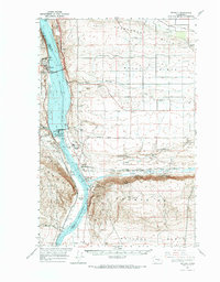
1965 Map of Beverly
USGS Topo · Published 1966About this map
The Columbia River dominates this mid-1960s landscape, serving as the border between Kittitas and Grant counties. This era reflects a period of significant hydroelectric development, anchored by the Wanapum Dam and the controlled water levels of Wanapum Pond. The industrial and natural character of the region is evident in the transition from the irrigated reaches of the Royal Slope to the protected lands of the Columbia Nat Wildlife Refuge. Along the western bank, the Ginkgo Petrified Forest State Park and Ginkgo Museum highlight the unique geological heritage near Vantage. The transportation network of the day is anchored by the Chicago Milwaukee St Paul and Pacific railroad, which threads through the Sentinel Mountains at Sentinel Gap and serves the small riverside settlements of Beverly and Schwana.
Find a feature on this map
39 named features on this map. Tap any name to fly to it.
Don’t see what you’re looking for? This feature index may not catch every label — zoom into the map to look around manually.
Map Details
Editions of this 1965 Beverly Map
This is the sole edition of this map. No revisions or reprints were ever made.
Other maps of this area

1909 · Quincy
USGS Topo · 1:62,500

1910 · Quincy
USGS Topo · 1:62,500

1910 · Winchester
USGS Topo · 1:62,500

1911 · Red Rock
USGS Topo · 1:62,500

1912 · Beverly
USGS Topo · 1:62,500

1916 · Coyote Rapids
USGS Topo · 1:62,500

1917 · Priest Rapids
USGS Topo · 1:62,500

1920 · Colockum Pass
USGS Topo · 1:125,000

1922 · Colockum Pass
USGS Topo · 1:125,000

1936 · Hog Ranch Buttes
USGS Topo · 1:48,000