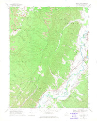
1968 Map of Beverly West
USGS Topo · Published 1971About this map
The Tygart Valley River corridor defines the eastern edge of this landscape, where the Western Maryland railroad follows the winding water through settlements like Beverly, Dailey, and Valley Bend. To the west, the steep slopes of Rich Mountain separate the river valley from the drainage of the Middle Fork and Roaring Creek. This late 1960s survey illustrates a rural mountain economy transitioning between traditional agriculture and industrial utility, with a prominent pipeline and several strip mines cutting across the ridges of Huttonsville and the surrounding heights.
Find a feature on this map
51 named features on this map. Tap any name to fly to it.
Don’t see what you’re looking for? This feature index may not catch every label — zoom into the map to look around manually.
Map Details
Editions of this 1968 Beverly West Map
3 editions found
Other maps of this area

1889 · Beverly
USGS Topo · 1:125,000

1892 · Beverly
USGS Topo · 1:125,000

1893 · Buckhannon
USGS Topo · 1:125,000

1896 · Buckhannon
USGS Topo · 1:125,000

1897 · Buckhannon
USGS Topo · 1:125,000

1909 · Elkins
USGS Topo · 1:62,500

1912 · Sago
USGS Topo · 1:48,000

1913 · Pickens
USGS Topo · 1:48,000

1914 · Sago
USGS Topo · 1:62,500

1915 · Pickens
USGS Topo · 1:62,500