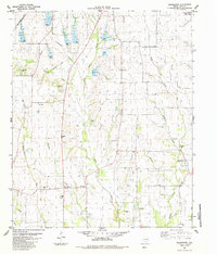
1984 Map of Biardstown
USGS Topo · Published 1984About this map
Biardstown and the surrounding Lamar County countryside are defined by a network of creeks and small crossroads settlements in the mid-1970s. The landscape is characterized by its agricultural character, interspersed with small community hubs like Glory, Atlas, and Frog Hop. Transportation history is clearly visible through the presence of the Atchison Topeka and Santa Fe railroad and a distinct Old Railroad Grade that cuts through the northern sections. Genealogists will find significant value in the documentation of several family and community burial grounds, including Mc Donald Cem, Antioch Cem, and Brackeen Cem. The terrain is marked by numerous watercourses such as Auds Creek, Hickory Creek, and Pecan Creek, which have historically influenced the placement of homesteads and local infrastructure like the Delmar Sch near Broadway Junction.
Find a feature on this map
31 named features on this map. Tap any name to fly to it.
Don’t see what you’re looking for? This feature index may not catch every label — zoom into the map to look around manually.
Map Details
Editions of this 1984 Biardstown Map
This is the sole edition of this map. No revisions or reprints were ever made.
Other maps of this area

1903 · Paris
USGS Topo · 1:125,000

1948 · Paris
USGS Topo · 1:62,500

1949 · Paris
USGS Topo · 1:62,500

1953 · Texarkana
USGS Topo · 1:250,000

1956 · Texarkana
USGS Topo · 1:250,000

1963 · Minter
USGS Topo · 1:24,000

1964 · Pattonville
USGS Topo · 1:24,000

1964 · Blossom
USGS Topo · 1:24,000

1964 · Charleston
USGS Topo · 1:24,000

1964 · Cooper North
USGS Topo · 1:24,000