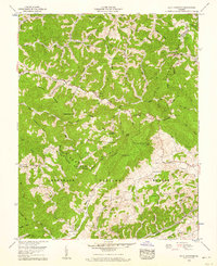
1958 Map of Big A Mountain
USGS Topo · Published 1960About this map
Big A Mountain stands as a prominent landmark along the Tennessee Valley Divide, where the rugged border of Buchanan and Russell Counties follows the ridgelines. In this 1950s landscape, small mountain communities like Council and Venia are connected by narrow roads winding through deep hollows carved by Hurricane Creek and the Russell Fork. The map reveals a highly localized social fabric, defined by dozens of family cemeteries such as Presley Cem, Ball Cem, and Tiller Cem, alongside numerous country schools including Fletcher Ridge School and Crabtree Sch. The southern portion is dominated by the Jefferson National Forest, while evidence of the region's industrial transitions appears via a Strip mine and the Norfolk and Western rail line. This survey captures a moment when the Helen Henderson Highway served as the primary artery through a landscape still largely defined by ridge-top agriculture and hollow-based settlements.
Find a feature on this map
105 named features on this map. Tap any name to fly to it.
Don’t see what you’re looking for? This feature index may not catch every label — zoom into the map to look around manually.
Map Details
Editions of this 1958 Big A Mountain Map
Other maps of this area

1886 · Grundy
USGS Topo · 1:125,000

1890 · Grundy
USGS Topo · 1:125,000

1891 · Tazewell
USGS Topo · 1:125,000

1891 · Abingdon
USGS Topo · 1:125,000

1892 · Grundy
USGS Topo · 1:125,000

1894 · Abingdon
USGS Topo · 1:125,000

1895 · Tazewell
USGS Topo · 1:125,000

1897 · Tazewell
USGS Topo · 1:125,000

1897 · Bristol
USGS Topo · 1:125,000

1902 · Bristol
USGS Topo · 1:125,000