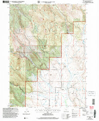
2004 Map of Big Baldy
USGS Topo · Published 2007About this map
Fremont National Forest dominates this section of Lake County, where high peaks like Big Baldy and Gilmore Peak define the upper elevations. The landscape transitions from these timbered heights down to the flats of the North Canal system, illustrating the management of water resources in Oregon’s high desert. This era of land use is visible through the infrastructure of cattle ranching and early forestry, with established homesteads and outposts such as Maxwell Ranch and Hotchkiss Ranch situated near reliable water sources like Bauers Creek and Camp Creek.
Find a feature on this map
27 named features on this map. Tap any name to fly to it.
Don’t see what you’re looking for? This feature index may not catch every label — zoom into the map to look around manually.
Map Details
Editions of this 2004 Big Baldy Map
This is the sole edition of this map. No revisions or reprints were ever made.
Other maps of this area

1955 · Klamath Falls
USGS Topo · 1:250,000

1958 · Klamath Falls
USGS Topo · 1:250,000

1964 · Lakeview NE
USGS Topo · 1:24,000

1964 · Crooked Creek Valley
USGS Topo · 1:24,000

1964 · Valley Falls
USGS Topo · 1:24,000

1964 · Cox Flat
USGS Topo · 1:24,000

1964 · Lakeview NW
USGS Topo · 1:24,000

1964 · Shoestring Butte
USGS Topo · 1:24,000

1964 · Drews Gap
USGS Topo · 1:24,000

1964 · Clover Flat
USGS Topo · 1:24,000