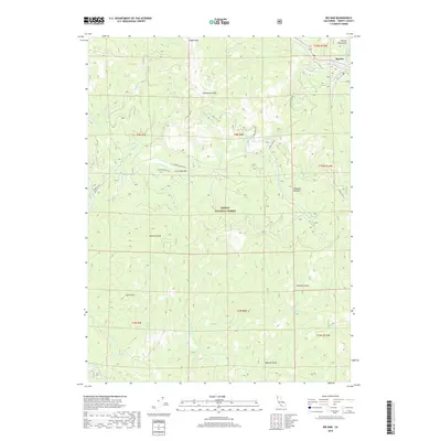
2018 Map of Big Bar
USGS Topo · Published 2018About this map
The Trinity River carves through the northern reaches of the Trinity National Forest, serving as the primary corridor for the settlement of Big Bar. This area of Trinity County is defined by its dramatic relief, where the Salmon Mountains and prominent summits like Eagle Rock and Monument Peak overlook a complex network of drainages. The map reveals the infrastructure of the timber and ranching era, with routes such as Old Corral Bottom Rd leading to the high-elevation flats of Corral Bottom. Water sources are abundant throughout the steep terrain, from the Haufork Creek in the south to smaller named features like Mud Spring and Haypress Meadow, illustrating how topography dictated the placement of early mountain roads and forest outposts.
Find a feature on this map
43 named features on this map. Tap any name to fly to it.
Don’t see what you’re looking for? This feature index may not catch every label — zoom into the map to look around manually.
Map Details
Editions of this 2018 Big Bar Map
This is the sole edition of this map. No revisions or reprints were ever made.
Other maps of this area

1909 · Big Bar
USGS Topo · 1:96,000

1915 · Big Bar and Vicinity
USGS Topo · 1:250,000

1951 · Hayfork
USGS Topo · 1:62,500

1951 · Helena
USGS Topo · 1:62,500

1951 · Hyampom
USGS Topo · 1:62,500

1951 · Ironside Mountain
USGS Topo · 1:62,500

1958 · Redding
USGS Topo · 1:250,000

1982 · Helena
USGS Topo · 1:24,000
1982 · Big Bar
USGS Topo · 1:24,000
1982 · Hayfork Bally
USGS Topo · 1:24,000