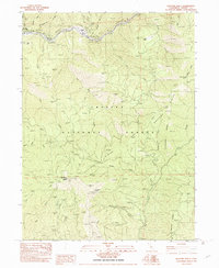
1982 Map of Hayfork Bally
USGS Topo · Published 1982About this map
The Trinity River winds through the northern reaches of this territory, where the small settlement of Big Bar sits along the banks. This portion of the Trinity National Forest is defined by the steep elevation gains toward Hayfork Bally, a prominent peak topped by the Hayfork Bally Lookout. The landscape is etched with numerous creeks and seasonal drainages, including Sailor Bar Creek and Packers Creek, illustrating a classic Pacific Northwest watershed pattern where ridge-top lookouts and river-bottom settlements were the primary human anchors.
Find a feature on this map
33 named features on this map. Tap any name to fly to it.
Don’t see what you’re looking for? This feature index may not catch every label — zoom into the map to look around manually.
Map Details
Editions of this 1982 Hayfork Bally Map
2 editions found
Other maps of this area

1909 · Big Bar
USGS Topo · 1:96,000

1915 · Big Bar and Vicinity
USGS Topo · 1:250,000

1951 · Hayfork
USGS Topo · 1:62,500

1951 · Helena
USGS Topo · 1:62,500

1951 · Hyampom
USGS Topo · 1:62,500

1951 · Ironside Mountain
USGS Topo · 1:62,500

1958 · Redding
USGS Topo · 1:250,000

1982 · Helena
USGS Topo · 1:24,000
1982 · Big Bar
USGS Topo · 1:24,000
1982 · Junction City
USGS Topo · 1:24,000