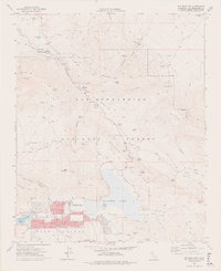
1971 Map of Big Bear City
USGS Topo · Published 1975About this map
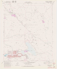
San Bernardino National Forest dominates this mountain landscape, where the early 1970s mining legacy of the San Bernardino Mountains meets mid-century recreational growth. The residential expansion of Big Bear City and Sugarloaf is evident along the southern edge of the dry Baldwin Lake basin. This survey documents a complex network of industrial activity, including the Doble Mine near the former settlement of Doble, and the Blackhawk Mine situated within Blackhawk Canyon. These mining sites, alongside the Santa Fe Mine and Silver Reef Mine, suggest an era of heavy mineral extraction that once defined the local economy before the shift toward residential and leisure development. Transportation and utility infrastructure are also prominent, featuring the Atchison Topeka and Santa Fe railroad line in the north and the Big Bear City Airport to the west. Local landmarks like the Drive-in Theater and the small Cem near Doble provide specific points of interest for genealogists and local historians.
Find a feature on this map
66 named features on this map. Tap any name to fly to it.
Don’t see what you’re looking for? This feature index may not catch every label — zoom into the map to look around manually.
Map Details
Editions of this 1971 Big Bear City Map
7 editions found
Other maps of this area

1901 · Southern California Sheet No. 1
USGS Topo · 1:250,000

1902 · San Gorgonio
USGS Topo · 1:125,000

1904 · Southern California Sheet No. 1
USGS Topo · 1:250,000

1947 · Lucerne Valley
USGS Topo · 1:62,500

1949 · Lucerne Valley
USGS Topo · 1:62,500

1953 · San Bernardino
USGS Topo · 1:250,000

1954 · San Gorgonio Mountain
USGS Topo · 1:62,500

1955 · Old Woman Springs
USGS Topo · 1:62,500

1955 · Morongo Valley
USGS Topo · 1:62,500

1956 · San Bernardino
USGS Topo · 1:250,000