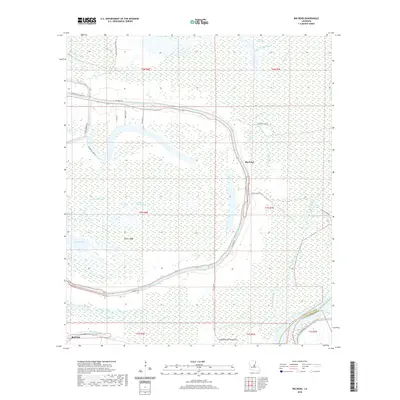
2020 Map of Big Bend
USGS Topo · Published 2020About this map
Big Bend and Red Fish anchor this low-lying landscape in the heart of Louisiana's river country, where the boundary between Avoyelles Parish and Pointe Coupee Parish meets the Atchafalaya River. The geography is defined by a dense network of sluggish waterways and wetlands, including the Pomme de Terre Swamp and numerous oxbow features like Sutton Lake. Higher ground is scarce, represented by features such as Sutton Ridge, while the human footprint follows the winding path of Bayou des Glaises and roads like Hamburg Rd. The map illustrates a classic floodplain environment where drainage and land use are dictated by the natural levees of the bayous. Geologists and local historians can observe the intricate hydrography of the region, from the winding Bayou Courville to isolated basins like Lac Patassa and Tilden Lake.
Find a feature on this map
39 named features on this map. Tap any name to fly to it.
Don’t see what you’re looking for? This feature index may not catch every label — zoom into the map to look around manually.
Map Details
Editions of this 2020 Big Bend Map
This is the sole edition of this map. No revisions or reprints were ever made.
Other maps of this area

1939 · Artonish
USGS Topo · 1:62,500

1941 · Voorhies
USGS Topo · 1:62,500

1941 · Batchelor
USGS Topo · 1:62,500

1953 · Natchez
USGS Topo · 1:250,000

1954 · Artonish
USGS Topo · 1:62,500

1954 · Baton Rouge
USGS Topo · 1:250,000

1955 · Artonish
USGS Topo · 1:62,500

1955 · Batchelor
USGS Topo · 1:62,500

1955 · Odenburg
USGS Topo · 1:62,500

1956 · Natchez
USGS Topo · 1:250,000