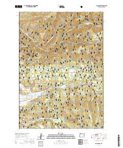
2020 Map of Big Canyon
USGS Topo · Published 2020About this map
The Malheur National Forest dominates this section of the Aldrich Mountains in central Oregon, where a complex network of springs and canyons defines the high-altitude terrain. Notable for its many water sources, the landscape is dotted with named springs such as Steagall Spring, Foster Spring, and Whitewater Spring, which feed into various creeks and the Byron Ditch. These water features likely supported the high-mountain ranching and logging economies that historically shaped this region. Natural clearings and distinct geological formations like Wendling Glade, Powell Meadow, and Table Mtn are scattered throughout the forest, while the southern portion of the map opens into the broader expanse of Bear Valley. The area is bisected by the Natl Forest Develop Road 16 Rd, which provides primary access to the dense topography surrounding the namesake Big Canyon.
Find a feature on this map
41 named features on this map. Tap any name to fly to it.
Don’t see what you’re looking for? This feature index may not catch every label — zoom into the map to look around manually.
Map Details
Editions of this 2020 Big Canyon Map
This is the sole edition of this map. No revisions or reprints were ever made.
Other maps of this area

1940 · John Day
USGS Topo · 1:62,500

1943 · John Day
USGS Topo · 1:62,500

1955 · Canyon City
USGS Topo · 1:250,000

1959 · Canyon City
USGS Topo · 1:250,000

1959 · Prairie City
USGS Topo · 1:62,500

1961 · Logan Valley
USGS Topo · 1:62,500

1961 · Seneca
USGS Topo · 1:62,500

1972 · Canyon Mtn
USGS Topo · 1:24,000
1972 · Pine Creek Mtn
USGS Topo · 1:24,000

1978 · John Day
USGS Topo · 1:100,000