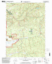
1998 Map of Big Canyon
USGS Topo · Published 2000About this map
Malheur National Forest dominates this late-twentieth-century landscape in Grant County, where the high terrain of the Strawberry Range and Aldrich Mountains converges. The map documents a complex network of forest resources and hydrology, featuring numerous named water sources such as Garden Meadows Lake, Whitewater Spring, and Steagall Spring. Local history and land use are marked by sites like Parish Cabin and the point labeled Wickiup, alongside several quarries that indicate the area's geological and industrial utility. In the southern portion, the open expanse of Bear Valley contrasts with the steep drainages of Big Canyon and Crawford Gulch. This 1998 revision, managed by the Burns Ranger District and Bear Valley Ranger District, also highlights the protected Strawberry Mountain Wilderness along the northern boundary, showing the balance between conservation and active forest management.
Find a feature on this map
34 named features on this map. Tap any name to fly to it.
Don’t see what you’re looking for? This feature index may not catch every label — zoom into the map to look around manually.
Map Details
Editions of this 1998 Big Canyon Map
This is the sole edition of this map. No revisions or reprints were ever made.
Other maps of this area

1940 · John Day
USGS Topo · 1:62,500

1943 · John Day
USGS Topo · 1:62,500

1955 · Canyon City
USGS Topo · 1:250,000

1959 · Canyon City
USGS Topo · 1:250,000

1959 · Prairie City
USGS Topo · 1:62,500

1961 · Logan Valley
USGS Topo · 1:62,500

1961 · Seneca
USGS Topo · 1:62,500

1972 · Canyon Mtn
USGS Topo · 1:24,000
1972 · Pine Creek Mtn
USGS Topo · 1:24,000

1978 · John Day
USGS Topo · 1:100,000