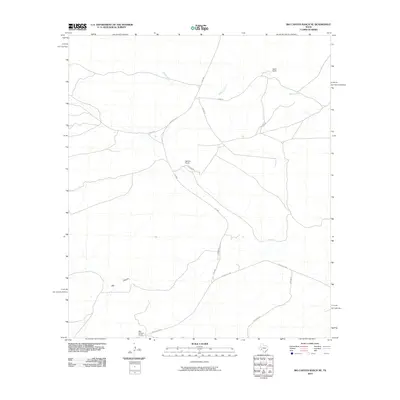
2010 Map of Big Canyon Ranch NE
USGS Topo · Published 2010About this map
Big Canyon defines the southern landscape of this West Texas territory, where large-scale ranching operations anchor the local geography. The map documents the sprawling infrastructure of established homesteads including Big Canyon Ranch, Word Ranch, and Harkins Ranch, which are connected by a network of rural routes like Harkins Rd and Corder Rd. This 2010 survey illustrates the modernization of ranching transit, showing the path of Ranch Rd 2400 and FM 2886 through the arid terrain. The drainage of McKay Creek provides a focal point for understanding the water management and topographic challenges of this Pecos County region. The relationship between isolated ranch dwellings and the arterial roads like Huckaby Rd reveals the enduring pattern of remote Texas land ownership in the early 21st century.
Find a feature on this map
13 named features on this map. Tap any name to fly to it.
Don’t see what you’re looking for? This feature index may not catch every label — zoom into the map to look around manually.
Map Details
Editions of this 2010 Big Canyon Ranch NE Map
This is the sole edition of this map. No revisions or reprints were ever made.
Other maps of this area

1928 · Sanderson
USGS Topo · 1:125,000

1929 · Independence Draw Quadrangle
USGS Topo · 1:125,000

1954 · Fort Stockton
USGS Topo · 1:250,000

1958 · Fort Stockton
USGS Topo · 1:250,000

1969 · Circle Dot Ranch
USGS Topo · 1:24,000

1969 · Big Canyon Ranch
USGS Topo · 1:24,000

1969 · Big Canyon Ranch NW
USGS Topo · 1:24,000
1969 · Big Canyon Ranch SW
USGS Topo · 1:24,000
1969 · Seventeen Ranch
USGS Topo · 1:24,000
1969 · Hackberry Draw SE
USGS Topo · 1:24,000