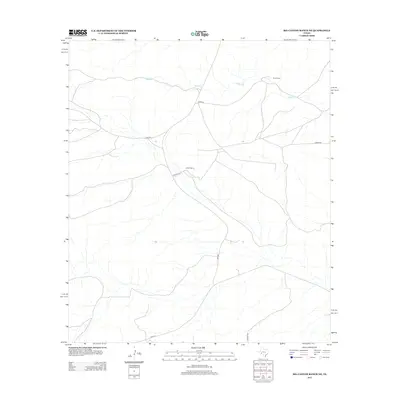
2012 Map of Big Canyon Ranch NE
USGS Topo · Published 2012About this map
Word Ranch and Harkins Ranch define the human footprint in this expansive portion of Pecos County, where the landscape is primarily shaped by an intricate network of drainage ways feeding into McKay Cr. This 2012 survey illustrates the remote ranching infrastructure of West Texas, dominated by long secondary routes such as Word Rd, Harkins Rd, and Thorn Rd that connect isolated properties. The map captures a high degree of hydrographic detail, tracing the seasonal watercourses that carve through the terrain. Civil connectivity is maintained by state-managed roads like Fm-2886 and Fm-2400, which intersect with older local tracks like Corder Rd and Huckaby Rd, marking the persistent boundaries and access points of large family landholdings in the Trans-Pecos region.
Find a feature on this map
10 named features on this map. Tap any name to fly to it.
Don’t see what you’re looking for? This feature index may not catch every label — zoom into the map to look around manually.
Map Details
Editions of this 2012 Big Canyon Ranch NE Map
This is the sole edition of this map. No revisions or reprints were ever made.
Other maps of this area

1928 · Sanderson
USGS Topo · 1:125,000

1929 · Independence Draw Quadrangle
USGS Topo · 1:125,000

1954 · Fort Stockton
USGS Topo · 1:250,000

1958 · Fort Stockton
USGS Topo · 1:250,000

1969 · Circle Dot Ranch
USGS Topo · 1:24,000

1969 · Big Canyon Ranch
USGS Topo · 1:24,000

1969 · Big Canyon Ranch NW
USGS Topo · 1:24,000
1969 · Big Canyon Ranch SW
USGS Topo · 1:24,000
1969 · Seventeen Ranch
USGS Topo · 1:24,000
1969 · Hackberry Draw SE
USGS Topo · 1:24,000