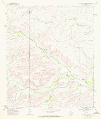
1969 Map of Big Canyon Ranch NE
USGS Topo · Published 1972About this map
Pecos Co Terrell Co boundary lines divide this remote West Texas landscape, where the seasonal drainage of McKay Creek and the deep cuts of Big Canyon dominate the topography. The map documents a sparse, high-plains ranching environment at the close of the 1960s, centered on the Word Ranch and Harkins Ranch. These isolated holdings are supported by a thin network of unimproved roads and essential livestock infrastructure, including a Corral and a designated Landing Area for light aircraft. An Indefinite Boundary and scattered elevation benchmarks like BM 3073 reflect the surveyor's efforts to chart this arid terrain where water sources, such as a solitary Well and a Gravel Pit, are the primary markers of human utility.
Find a feature on this map
15 named features on this map. Tap any name to fly to it.
Don’t see what you’re looking for? This feature index may not catch every label — zoom into the map to look around manually.
Map Details
Editions of this 1969 Big Canyon Ranch NE Map
This is the sole edition of this map. No revisions or reprints were ever made.
Other maps of this area

1928 · Sanderson
USGS Topo · 1:125,000

1929 · Independence Draw Quadrangle
USGS Topo · 1:125,000

1954 · Fort Stockton
USGS Topo · 1:250,000

1958 · Fort Stockton
USGS Topo · 1:250,000

1969 · Circle Dot Ranch
USGS Topo · 1:24,000

1969 · Big Canyon Ranch
USGS Topo · 1:24,000

1969 · Big Canyon Ranch NW
USGS Topo · 1:24,000
1969 · Big Canyon Ranch SW
USGS Topo · 1:24,000
1969 · Seventeen Ranch
USGS Topo · 1:24,000
1969 · Hackberry Draw SE
USGS Topo · 1:24,000